Sunday, March 31, 2019

Keeping the cold at bay: Gila hotsprings


After paying another visit to the visitor centre – as usual I couldn't tear myself away from the book section – we, too, headed into the (somewhat) lower area to enjoy 
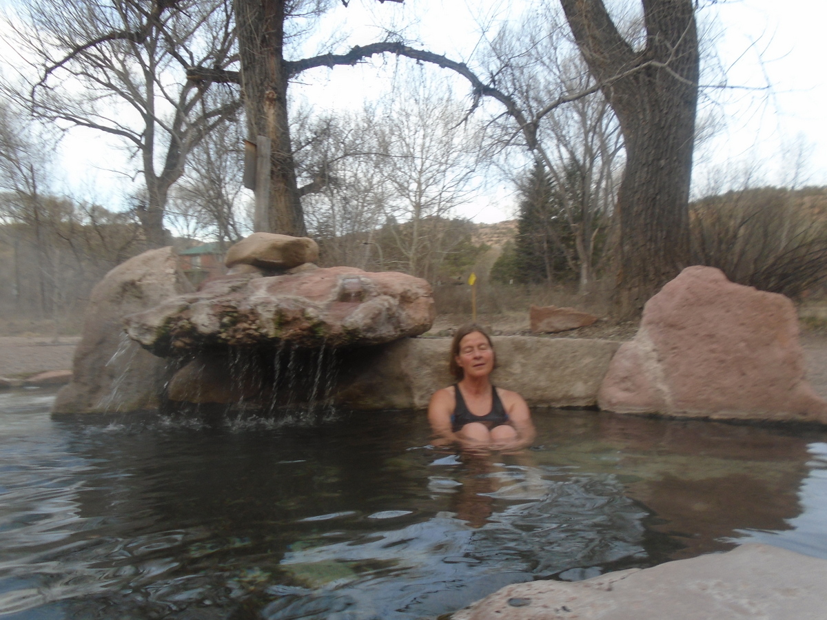
some easy living: we had booked a spot at the Gila Hot Springs Campground for the night, a privately owned, small campground right by the Gila river. Carla, the owner, welcomed us and sent us to our camping spot, nicely treed, with soft sand as a very nice base for our tent. For US $8 per person we could not only put up our tent for the night but also soak in one of three hot pools as long as we wanted or could stand it. This would come in very handy tonight since it was supposed to get cold, likely below freezing.

We took advantage of this when the sun was about to slip below the rocky walls in the west and it started to get cooler. Allen, Carla's husband, like her looking to be in his seventies, paid us a visit and told us that these three hot springs were in fact hot pools they built, fed by hot water they piped down from the hills behind us. The water is about 65 degrees Celsius where it comes out of the ground, but by the time it reaches the pools it is 59 or 60 degrees.
For us it was perfect, and while there were a few other campers – not many: the campground has only twelve camping spots, and some of them were empty – nobody felt inclined to use the pools just then, so we were all by ourselves. Slowly the stars came out, first only here and there, but by the time we were ready to leave the pool the whole sky was ablaze with light. Rarely have I seen so many stars! The bright stars in Orion and Sirius seemed to be surrounded by halos and huge, much brighter than they normally seem to be. Although it was quite cool by now we were totally warmed through, and, armed with wool socks and a layer more than I usually wear in my cozy sleeping bag I wasn't cold at all that night.
Johann's bathing trunks frozen stiff after 'drying' draped over the pickup box overnight

The next morning was a different story. In this narrow valley it would take a good long while for the sun to find its way here. The hot pools were waiting, but to leave the warmth of the sleeping bag to walk the fifty metres or so and then put on a cold bathing suit took some determination. Still, we couldn't stay in the tent forever, and the hot water was beckoning, so once the thin sliver of moon had cleared the canyon wall in the east the sun had at least to be thinking of making its appearance, and the intervening time would best be spent in the hot water, we decided.

Dragon water spout for drinking water (hot as well)


By the time the moon had faded and the sun sent its first warming rays onto our picnic bench we were packed and ready to go. 


We had not too long of a drive ahead, so we decided 
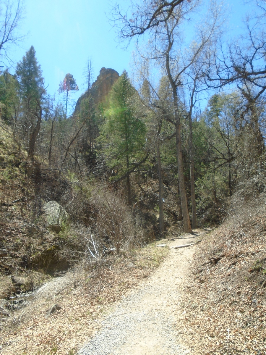
to follow the recommendation of the ranger and seek out S.A. canyon, accessible from the Grapevine trailhead a bit further down the Gila river, not far from where we had camped. 'It's a neat place to walk,' she had told us, ' a narrow canyon where you can find crystals.'

It was indeed a nice walk, maybe a kilometre along the rocky canyon bottom where, as promised, we soon saw sparks of light reflected from the rocks with their crystal inlays. A tiny creek appeared seemingly out of nowhere, and we crossed it back and forth following it up to a deeper pool fed by a little waterfall. This was where the hike ended for us: there was no foothold anymore, and the water was too cold to consider wading through up to our thighs. We sat near some blooming wild gooseberry bushes for a bit, teeming with bumblebees happy for the first source of food of the season. A bit further down I found a blooming maple – spring is definitely in the air along the Gila river.

Johann's hope to find a trailhead to hike for a bit along the Continental Divide Trail on our way along Hwy 35 towards our next destination was not fulfilled; while we crossed the divide we could find no marked trail. What we did find, a while later, was the Emory Pass at the top of another winding climb along a very scenic route. At nearly 2,500m the viewpoint just above the pass provides a great view of the area to the north.

We found a motel room on the outskirts of a place with a very strange name: Truth or Consequences, short T or C, originally named Hot Springs because of the artesian wells with heavily mineralized water that flow freely in several places in this town.

A glimpse of the past: Gila cliff dwellings

After yet another wonderfully satisfying Mexican breakfast, which surely would sustain us for much of the rest of the day, we left Silver City a couple of days ago. I really liked this medium-sized town that felt like a place where I could live – not that I am looking for one. The landscape speaks to me with its tones of silver greens and greys and gently rounded hills. Depending into which direction one looks, however, there are also less beautiful things: as in any area rich in mineral resources mining has left its scars, sometimes visible from far away. Much as I lament this I can't rightly complain about it: I use these resources and am thankful that they are available, after all.


We took Hwy. 15 out of town, which immediately begins to climb through beautiful, forested country towards Pinos Altos (High Pines, a very fitting name since this area is home to large stands of Ponderosa pine). This is an interesting little town, almost deserted now but once obviously with grand aspirations: the 'opera house' and other buildings give witness to that. 

Once again we crossed the continental divide on this very curvy, very narrow road that had me hold my breath in a few places. If possible I avoided looking too closely when we rounded yet another hairpin curve, a steep drop right beside me, another pickup coming towards us just at that very moment. I was much too taken with the scenery, however, to worry much, and with Johann's slow and careful driving I felt quite safe. There was very little traffic, which, I imagine, will change in the summer. 


After about three quarters of an hour we reached the intersection with Hwy. 35 near Lake Roberts, and from then on the road was a bit wider and had a centre line. We continued to climb, but the landscape became more open, with gorgeous views from the ridge. Finally we started one long downhill stretch towards the Gila river and headed for the Gila cliff visitor centre, not very big but nicely set up with displays, a small room to watch a video of the Gila cliff dwellings and a well appointed book section. The helpful rangers gave us some good advice where to hike in the area, plus some instructions regarding the Gila cliff area itself, and we soon were on our way to see this very special place for ourselves. 

There is another small visitor centre right at the foot of the cliffs, and the ranger there gave concrete instructions to everybody visiting the ruins, pointing out that another ranger was up at the top to answer any questions arising there. The whole loop is a mile long and takes only about an hour to complete, and since we had about two and a half hours until closing time we walked slowly, enjoying the signs of spring now apparent everywhere: golden fumitory, the small herbaceous plant that had caught my eye on several occasions on our hikes around Silver City, buffalo bean, wild gooseberries and honeysuckle leafing out, even a single dandelion. 


The trail up ascends slowly along a little creek before the last steeper ascent via stone stairs. Here and there on the way up one can catch glimpses of the caves built into the cliffs about 55m above the canyon floor. 


Up at the top we walked on firm rock along the cave entrances. Here, members of the ancient Mogollón people built their pueblos inside these caves with rocks, mortar and timber somewhere in the late thirteenth century. There are a lot of unknowns because there are no written records nor oral traditions that explain exactly why they moved into these dwellings and chose to live high up in this canyon. It is assumed, however, that a 25-year drought and the resulting economic uncertainties and warfare caused a group of people to flee the lower lying areas and seek shelter here. It cannot have been an easy life: water had to be carried up from the creek below, and they grew corn on the mesa across the canyon, which is at about the same height as, if not higher up from the canyon bottom than the cliff dwellings. 


They built walls along the cave entrances and inside, creating rooms of different sizes that housed up to sixty people altogether. In most cases the walls don't reach all the way up to the cave ceiling but end about 50cm below so that the smoke from the fires used for heat and cooking could escape; the cave ceilings are blackened from it. The caves would have provided reasonably good protection from both the summer's heat and the winter's cold. 
Ancient cobs of corn
 Petrified corn has been found around the caves, and genetic testing proved that it was grown in the time when the Mogollón people settled here. Most of their food would have come from fishing, hunting and gathering, subsidized with the corn grown on the mesa. Pottery found in the caves showed that these people likely came from the Tularosa region about 60 miles to the north rather than being closely connected to the Mimbres people southeast of the Gila cliff dwellings, and finds of macaw feathers suggest that their trade routes went all the way down to central America. 


One of the caves has a t-shaped doorway found in the pueblo cultures further south but not often here, so this, too, shows a likely connection to other peoples of the Southwest. In one of the caves a few petroglyphs can still be found; we saw two depictions of men and one of a snake.

The inhabitants of these caves moved away after only a few decades around 1300. Why? Nobody can say for certain, but it was a time of many migrations in the Southwest, and likely the climatic and resulting economic conditions improved so that the cliff dwellers moved on to areas where the living was easier.

Friday, March 29, 2019

In and around Silver City, New Mexico


The past two days we've spent in a cute little log cabin in a KOA campground just outside of Silver City, NM. This is a new experience for us (just like the AirBnB, but at least this one we were aware of beforehand), and it's been a very good one. The campground is not overly big and at this time of year fairly empty still, it is very well kept, clean and reasonably priced. It's a nice change from the motels in the middle or at the edge of towns because it is nice and quiet, I can hear the red-winged blackbirds and other songbirds early in the morning already, and the air is fresh and clean. It's been truly relaxing for us here, and a good place for Johann to lay low for a bit to try and get over his cold.


 Silver City must have been a booming town in the late 19th century because of its silver mining. It's well worth spending a morning walking through its nicely restored historic core and look at the buildings left from its heyday. Plaques describe the history of different buildings, and it's hard to imagine that this period of affluence lasted only a few years. Several economic crises, the most devastating the collapse of the silver market starting in 1893. Merchants built empires and lost them again in the span of a few years. It wasn't only the economic instability they had to deal with but also calamities like fires ravaging the wooden buildings in the city and a terrible flood washing away parts of downtown, creating a deep gully that cut right through the town. Today, this 'big ditch' provides an area for pleasant walks, which we were able to check out when we crossed the foot bridge not far from the attractive tourist office to downtown. 


The tourist office has ample parking space, and visitors to Silver City are encouraged to leave their vehicles there and explore the town's core on foot. Some neat restaurants and many art galleries can be found there; Silver City has developed into a thriving arts community since the seventies. There are still empty buildings around town, but it seems that it has found its new calling after the decline more than a hundred years ago. 

Yesterday morning we drove up the hill the WNMU (Western New Mexico University) to visit the university museum. It is located in a beautiful building that has seen many transformations since its beginnings in the late 19th century. Most notably, maybe, it had a basketball court on the main floor with a gallery for spectators, while the chemistry labs were in the floor below. This former basketball court now houses a collection of the pottery of the Mimbres culture who lived in this area for about a thousand years and suddenly seem to have disappeared a thousand years later around 1100. The collection is so special because all the items come from a small area instead of having been brought together from different places further away. Bowls and containers of all kinds show the development of the techniques used to make them, some with geometric designs, others depicting animals and humans or Kokopelli, the humpbacked flute player. This godlike kachina spirit was supposed to have been responsible for bringing corn to the people and making it thrive.


Both afternoons we went on hikes not far from here. Two days ago our destination was the 'Big Tree', a 600 year old juniper. The trail led us through the typical landscape of shrub cedar, pinion pine, juniper evergreen trees with small hard, dry, pointed leaves that I still need to identify. 


The grass is still brown, but small plants are starting to green everywhere, and here and there verbenas are blooming. The juniper we had come to find was enclosed by a rail fence with an opening for people but not for animals: these grasslands are used by cows, plus, of course, deer, coyotes and other small mammals. I stretched my arms and measured: I needed four full arm spans to go around once, which means that the tree's diameter is at least two metres. What must that tree have seen already! 


Not far from it stood an oak, no smaller and likely no younger but no longer alive, the matriarch in this thicket of young oaks. A little creek trickled not far from it, and it was hard to believe that it could provide the moisture needed for all these big trees, the landscape along its banks completely different from the one we had traversed to get here.


It had been overcast, without any threat of rain almost a bit gloomy all day, but on our way back to the campground the sun tried to make an appearance, attended to by a sun dog or parhelion. I had observed that only once before, at home on a bitter cold day with ice fog. A nice way to end the day!

Yesterday's quest was a dragonfly pictograph along a trail of the same name. 


The trailhead was closer to our campground yet, and the landscape more open at first. This time the sun shone in a deep blue sky, and despite the wind it was quite warm. 


The trail, much better marked than the one the day before, descended to a valley with huge old cottonwoods after a while and led along a little creek making its way along big boulders. Following the signs we walked alongside it for a while, waiting for a marker that would show us the way to the pictograph, but in vain. 


After a while the trail climbed up to the dry, open flats again, and we realized we had missed it. I was a bit disappointed, but it had been such a nice walk that it was not worth getting upset about it. Still, it's hard to believe that whoever is responsible for marking the trail didn't point out its main focus.

Now we're getting ready to leave. We'll spend the next night in a tent at the Gila cliff hotsprings about an hour and a half north of here. I look forward to finding out more about that area with its cliff dwellings.


Thursday, March 28, 2019

On the way to New Mexico: A visit to the Boyce Thompson Arboretum

We left our friends in Mesa three days ago. Since we had chosen Globe to spend the night we had plenty of time: it's only about an hour's drive. We were in no immediate hurry to leave the Arizona desert; wherever we headed for next it was bound to be cooler.

I fondly remembered the visit to the Boyce Thompson arboretum just west of Superior from a few years ago, and since it was right on our way we made that our excursion for the day. Johann was happy to stay in the seating area near the entrance and read while I spent time with the many cacti, agaves, succulents and other desert plants in this beautiful botanical garden, one of the oldest west of the Mississippi and the largest and oldest in Arizona. It was founded in by Colonel William Boyce Thompson in 1924 as a desert plant research facility and is situated on 392 acres.


With no particular agenda beyond simply enjoying what I saw I walked slowly, taking smaller trails branching off the main one to see what I would find. There are, for instance, the Chihuahua trail, the one leading to the legume section – extensive, populated by all kinds of pod-bearing plants of the desert, from the many different kinds of acacia to the mescal bean, covered in clusters of sweet-smelling purple blossoms - , the agave section, a South Africa, South America and Australia section, and even a (man-made) lake, Lake Ayer, home to many water birds, fish and amphibians. Wherever I liked it and it was quiet I sat on a bench in the shade for a while, watching the butterflies and bees at work, taking in the many different shapes and textures.

At the lake I received a very special gift: a flash of bright red caught my eye, a male cardinal in search of something to eat. He was not shy at all, and soon he was joined by the female, as usual in the bird world less flashy, but still very pretty. I could watch them for several minutes before a noise startled them and they flew off.

In the cactus section I was happy to find my favourites, the globe cacti, huddled close together against a rock wall and interspersed with many different other cacti like the fish-hook cactus, the hat-needle cactus, the hedgehog, prickly pear, blind pear, and so many more.

Some time I spent in the Eucalyptus cove, a shady, cool place dominated by huge red gum Eucalyptus trees. It was hard to believe that these trees could grow in the desert, and they probably couldn't if it weren't for the fact that this is a riparian zone.
An odd-looking fellow: the Boojum tree, belonging to the Ocotillo family

To take everything in the two hours I spent at the arboretum would not be enough, but for me it had been just what I needed to wind down after the intense hike the day before.

In Globe we found out that there were no hotel rooms available due to a mine closure (not sure what influence that has on hotels, but that's what we were told), except excessively expensive ones. It was still relatively early in the afternoon, so we kept going towards Safford where, we were told, there would be no shortage of beds, and it would be cheaper.

East of Globe the road climbed slowly, and we were treated to the most amazing display of wildflowers in bloom. The orange-gold and purple was a feast for the eyes. Thinking that this would continue indefinitely I didn't stop once to take a picture, and I could kick myself now: whatever came after these hills couldn't measure up to what we saw there, and I doubt that we'll find another place like that now. All of a sudden the landscape changed completely. First we passed through rather desolate looking country, the houses in the little communities dilapidated, often boarded up, surrounded by old cars and other junk. Then it changed again and gave way to agriculture, something we hadn't seen probably since Idaho. Tractors were cultivating fields, irrigation ditches were running, some fields, obviously some kind of grain, were lush and green. Hilled fields looked like they would be planted with potatoes, but Johann read up on it in the meantime and found out that it is cotton growing country. Strangely, to me the somewhat desolate feel remained, I don't quite know why. Maybe when all the fields were green it would be different? I liked the natural high desert with its silver-green or grey shrubs stretching into the distance towards the high mountains better.

In Safford we indeed found a place to stay for the night, albeit not a hotel that served breakfast, so we kept going until the far southeast corner of Arizona where we passed through a small town named Duncan. It, too, had obviously seen better days, but at 'Hilda's Kitchen and Meat Market' we got an excellent late breakfast/early dinner. The place was interesting, old and a bit run down but huge, the server probably more proficient in Spanish than English. For Mexican food lovers like me we had now arrived in the right area, and the Huevos Rancheros were delicious.

Thus fortified we had no trouble driving the rest of the way to Silver City, NM, where we have spent the last two days in a cabin at a very nice KOA campground, at this time of year not very busy yet. 

Wildflower bloom in southwestern New Mexico