For our second day in St. George we had planned to do some
hiking in Snow Canyon State Park, which is just outside St. George. In the
morning we visited the wildlife museum in the Dixie Centre where we had stopped
the day before. Somehow the mention of ‘live animals’ had led us both to think
that the ‘animals from all over the world’ were indeed alive, and even when we
talked to a man while we waited for the museum to open and he told us he was
looking after the bug room I had visions of live bugs. We were soon cured of
that notion: ‘live’ refers to the animals’ having been alive once vs.
artificially created models. It is an extremely well stocked exhibition of
animals from all over the world, hunted (harvested was the word used) and
stuffed in life-like positions and situations, including, for instance, a
mountain lion in the process of killing a mule deer, but nearby another
situation where the hunter becomes the victim, the mountain lion is impaled on
the antlers of a buck. It is very well designed and set up, and there is a lot
of information about the animals displayed, but I have a bit of a hard time
looking at so many trophies, thinking how much killing this involved. Yet it is
made very clear that hunters contribute a huge amount of money to the
conservation of animals, of whole animal species, which, I think, is not common
knowledge. There were many different kinds of sheep and antlered animals from
all over the world, some I had never heard of.
After the audio guided tour we were happy to get back out
into the sunshine, however, and eager to get away to real ‘live’ animals and
plants: Snow Canyon was waiting for us to explore. We followed Snow Canyon
Parkway out of town, the houses more expensive and beautiful the higher we got.
Much care is taken to keep the overall look of the landscape as little
disturbed as possible, by working with the colours, textures and materials that
were there before all these developments started. I read that St. George is the
fifth-fastest growing city in the United States: it is a much sought-after
retirement community that has much going for it, from its climate to the
proximity of several beautiful national and state parks. A vibrant art scene
has developed, which is another attraction. Most of the residents are
Americans, but there is a small Canadian contingent as well. We met people from
Wetaskiwin, south of Edmonton, who spend several months here every winter.

We had hardly left the residential neighbourhoods when we
turned off to the right and soon reached the park entrance. Six dollars gained
us access for the day and a trail map. The advice to take Hidden Pinyon trail
came for free.

Hidden Pinyon, according to the trail guide, was a 1.5 mile
self-guided nature trail, but after talking to a couple wearing vests informing
that they were ‘Friends of Snow Canyon’ – a volunteer group that is looking
after trails, aiding visitors like us with advice, but, as I read later, also
involved in fundraising – we decided to make the loop a little bigger by
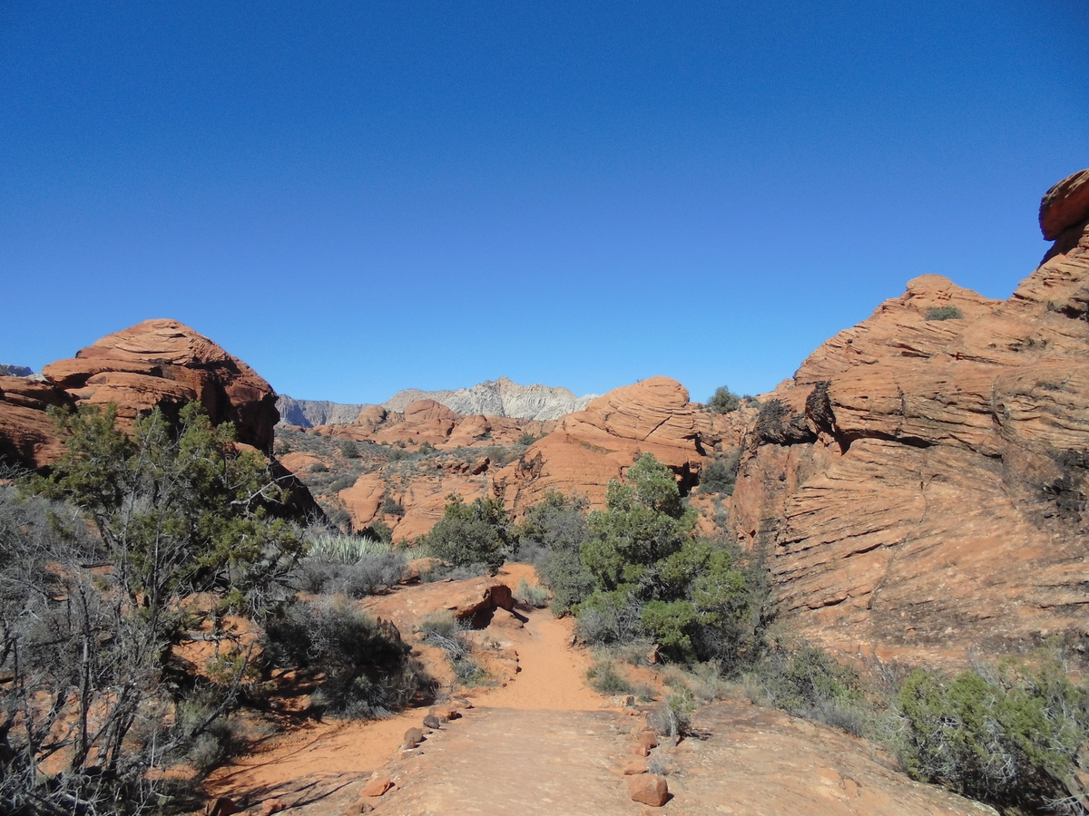
connecting to Red Sands trail. Just like in Valley of Fire we walked in very
fine, deep sand for a while, which is a bit strenuous, but soon the path became
rocky and the hiking easier. Here, birds seemed to be everywhere, and their
songs sounded from the shrubbery on both sides of the trail. We had picked up a
brochure that explained about the flora and fauna of the trail; some of the
plants were familiar to me, others not yet. To my delight we had to pass two
short slot canyons on the way as well.The views were again spectacular, reminiscent of other places we had visited like Red Rock Canyon and Valley of Fire; here, too, the rocks were multi-hued, the formations fantastic. After a good hour we were back at the parking lot and on our way to the next trailhead, a few miles up the road.

I had read about Lava Flow trail, where, in two places, it
is possible to enter the tubes where lava streamed through previously hardened
conduits. We had been in lava tubes on the Galapagos Islands, huge caves that
stretched for hundreds of metres, but it was intriguing to see them again here,
and we decided we might as well plan our hike so that we would pass by there.
We started out from the parking lot on ‘Butterfly’ trail, however, a two mile
hike that connects to Lava Flow trail. We didn’t see any butterflies yet, but a
couple of large rodents watching us from rock overhangs above. They didn’t look
quite big enough to be marmots, and the elevation isn’t high enough, so I think
they could have been rock squirrels. Some of their much smaller cousins –
desert rats or mice – scampered across the trail a few times during the hike as
well, and we spotted rabbits feeding on the new grass, too. How happy they all
must be that spring is around the corner.
 |
| Looking out from the lava tube entrance |
 |
| Johann can be seen climbing out at the far end |
We climbed down into the hole from where the lava tube can
be accessed and walked in as far as we dared with the dim light of the
headlamp. Exploring further would have meant clambering over uneven ground,
sharp rocks of varying sizes, into an ever-narrowing space, and we were not up
to that.

Lava Flow trail turned down into the valley in a large arc,
leading down a sandy hillside with small bushes, signs reminding hikers to stay
on the trails because of habitat restoration in progress. Wind, water and sun
are constantly working their erosive forces, and we as humans should aim to
have no more impact than absolutely necessary on this fragile environment,
which should go without saying. It seems people are keeping in mind that they
are stewards of this country, taking out what they brought in, leaving no garbage behind - unless the 'Friends of the Park' are solely responsible for the pristine condition of the trails.

On our way to the bottom we passed through a dry wash with
deep white sand. I had to stop and let it run through my fingers: it could have
easily been used for egg-timers, it was that fine. It would be really nice for
our grandchildren’s sandbox as well. We reached West Canyon Road, a wider road
with a firm surface used by cyclists, horseback riders and hikers, but also
accessible with a vehicle, I think. From here we had planned to turn back up
into the hills and get back to the parking lot via Red Sands and Petrified
Dunes trails.

The sun was low enough now to really bring out the warm
colours of the Navajo sandstone, and the slip rock walls of Petrified Dunes, upraised
sediments of an ancient sea, rose, glowing, in front of us. It was nice walking
on the slightly slanted surface, the view becoming better and better the higher
we got. As before, signposts showed where to go – until, at one point, it
became questionable: the route indicated by the last signpost led us high up to
the top of a steep section, with no discernible path leading down from it. We
tried a narrow wash where live shrub oak made walking difficult, their prickly
branches and leaves scratching hands and faces, only to face another dead end
from which an even more impassable canyon led up to another rim. Looking up, we
saw two people just starting to descend from there with great difficulty:
they, too, had lost their way and, unwilling to turn around at first, had found
themselves unable to go on. We searched for the right route, finally found another
trail marker and started to follow the new path, until once again we were at a
loss how to continue. It looked to us as if someone had deliberately moved the
markers slightly, which would be a really inconsiderate thing to do.

We
followed another, wider wash on our search for a marker. Other tracks showed
that people had walked here before, but after a while they, too, ended literally
‘in the sand’. We probably could have continued like this for a long time, but
we were tired and wanted to get back to the car, so we just scrambled up the
hillside to the next rim to see if we could spot the road we knew must be there
somewhere. And indeed, a paved trail – which could only have been ‘Whiplash’
trail, the only paved trail in the system – was right in front of us, the road
visible not far away. Happy to be on the right track again we turned left and
were back at our car in less than ten minutes.
It is not a bad thing to ‘get
lost’ for a little while; it brings back to mind that this is wild country
which needs to be taken seriously, not just a walk in the park. Here, we were
never far away from a parking lot or a road, even though it feels like it when
you have hiked for a few miles, but it still is wilderness, and one needs to be
prepared with water, adequate clothing and something to eat.

I have fallen in love with this landscape of the Red Cliff conservation area at whose edge St. George lies. Three distinct geographical zones
meet here: the Mojave Desert, the Colorado Plateau and the Great Basin Desert,
making for an amazing variety of plant and animal life. I can see why people
choose to move here for retirement, either for the winter or year-round.
No comments:
Post a Comment