Sunday, April 16, 2023

Where in the world are Massacre Falls?


A few years ago we chose Massacre Falls in the Superstition Mountains as one of our hiking destinations during our time in Mesa, and especially I really liked that hike. Then, it was a dry spring, the waterfall just a trickle. This year there might actually be a real waterfall since the area had received a lot of rain. We decided to check it out on Wednesday and save the big hike up the Flatiron for the next day. 

 We were on our own since Aaron and Evelyn went to a ballgame, but the instructions for the trailhead were pretty clear both from our online research and what we could find out in “60 Hikes Within 60 Miles of Phoenix”. We needed to go just past the entrance to Lost Dutchman Park, and the trailhead would be about a mile further on the right hand side. Parked cars in the small parking lot showed that we had arrived at our destination, and, armed with water and a few snacks we were on our way. There were no signs, and the trail split shortly after we started out, but it would be logical to take the wider of the two trails, wouldn’t it? The trail meandered through the valley for a good while without gaining much elevation before turning left and climbing a bit. We crossed “Jacob’s Cross Trail”, named, just like the Lost Dutchman Park itself, after the German prospector Jacob Waltz who mined for gold in this area in the 1890s. 

 Somehow this trail started to look quite different from what we remembered. We should have left the flats by now. Had we taken a wrong turn? We were not going to turn around, however, and kept going in the direction where we assumed the waterfall to be. With any luck we’d get to the right trail again after a while. Soon it became apparent that this was not going to happen if we continued on. We needed to gain elevation and keep roughly going east. When we were straight below the impressive rock formation called the “Praying Hands” – this is truly what they look like – we followed a not very well defined trail and, since we found a few small rock cairns, were somewhat reassured: somebody must have hiked here before. Soon, however, the trail disappeared completely. 

The Praying Hands

 There was nothing for it: we’d have to climb up the rocky draw to reach the trail leading east from the Praying Hands. We were still hoping to keep going east and eventually arrive at the falls. It was pretty hard work climbing up the draw, but every break to catch my breath rewarded me with the amazing view of the Superstition Mountains stretching into the distance. Spring flowers were in bloom, and the hillsides were green with new growth, greener than we had ever seen them before.


We arrived at the trail east of the Praying Hands just as a group of women walked up from the west. Would they be able to tell us if we could get to Massacre Falls this way? The leader, obviously well familiar with the area, thought we might be able to but said she had never accessed it from here before. Well, we’d just keep going as far as we could; maybe we would be lucky. If we followed the loop we would pass "Slot Rock", another massive rock formation, and then head back to the parking lot. 


When we got to the next butte (I think the woman we talked to called it ‘The Gargoyle’) we kept going east for a while longer, following the hardly visible trail, but when we lost it again and came to yet another draw that would be difficult to traverse we gave up: there would be no Massacre Falls for us this time. We turned around and kept following the much better marked trail that looped towards Slot Rock, marvelling at these massive rocks that seem to have shouldered their way straight out of the desert. What gorgeous country this is! 


The hillsides were purple with nodding onions, and the poppies, their golden blossoms folded on this mostly cloudy day, would surely be in bloom as soon as the sun came out. 

 After maybe another mile or mile and a half we arrived back at our car. Only now, when I read more about Massacre Falls, did I find out that the trailhead is no longer where it had been until about two years ago but has been moved. Had we researched a bit more beforehand we very likely would have found the elusive falls. It doesn’t matter: every hike here is rewarding, and there is so much more of the Superstition Mountains that we haven’t yet seen.


Sunday, April 2, 2023

A surprise encounter near Florence, AZ


Florence, about 100km southeast of Phoenix, seemed like a good place to take a break between the two planned visits and meant we didn’t have too far to drive either after our hike up Telegraph Mountain or the next day to get to our friends in Mesa, leaving time enough for a hike in the area.

With a population of about 26,000, it has no resemblance I could think of with its famous counterpart in Italy, but it was a pleasant enough location, surrounded by fields, with wide, rather quiet (at least right now) streets. It has quite a few historic buildings in its downtown core and is home to the second oldest courthouse in Arizona, now a State Park (McFarland building). Johann, who used the hour or so in the morning while I was updating my blog a bit to go for a walk, came back with the news that he had spent the entire time walking by a prison: the fence, he said, didn’t seem to end. After an hour-long wait for breakfast at the ‘Florence Café’, a restaurant I found recommended on tripadvisor (no mention of waiting times …) we stopped by the tourist information to get a recommendation for hikes. There, we found out that it was not one prison Johann had seen but a multitude: Florence, for some reason unknown to the lady at the tourist office, is home to prisons on every level, federal, state, county and private. 15,000 inmates stay in these prisons, more, she said, than the rest of the population. Later, I read that about two miles out of town was also an internment camp for German and Italian prisoners of war during WWII, while another facility, the Gila River War Relocation Centre, housed Japanese American ‘enemy aliens’ nearby. Why Florence? Maybe it is because of the fact that it borders on the desert, and escape would be difficult.


 We walked up and down main street once to take a quick look at the buildings and soon were on our way out of town. Our first stop was Poston Butte, a small rise not far from the outskirts of Florence that affords a good view of the surrounding area. The short half-mile hike itself is rather uninspiring, up a pretty steep incline, but masses of lupins and other wildflowers covered the rocky flanks of the butte, and with cloudy skies, even a slight sprinkle of rain, it was not too hot. At the top is the pyramidal tomb of the man who is called the founder of Arizona, Charles D. Poston. According to Wikipedia, he lobbied President Lincoln and congress to create the state of Arizona and was appointed Superintendent of Indian Affairs because of his familiarity with the Native population in the area. 

 
We turned back after a look around: it was windy and by no means warm up there. About half way down the trail Johann, who was walking in front of me, suddenly jumped back when a distinct rattling noise warned him to keep his distance: a rattle snake, more than a metre long, lay coiled up in the middle of the trail we had walked up only maybe fifteen minutes earlier. We watched how it slowly slithered to the side of the trail, now no longer alarmed by our presence, and continued on once it was safely on the other side. We wondered: what made Johann jump back? Had he heard the rattling first, or was it some kind of instinct we possess in these circumstances? I thought this was how I would want to have a bear encounter: to be close yet in no danger of being attacked. Of course there is no guarantee that the outcome would be like that, so it’s probably safest to hope for no close encounter, just like with rattlesnakes. 


After a half-hour drive northwest through an increasingly populated area we arrived at San Tan Mountain Regional Park, a recommendation we got at the tourist info in Florence. Here, a well-developed network of hiking trails offers ample opportunity for hikes of different lengths.

By now it was about four o’clock, so we had nearly four hours of daylight, which would have been enough even for the steep climb up Goldmine trail. Neither one of us felt like engaging in too strenuous exercise today, however, and we turned off Goldmine trail to continue on a section of the longest trail of the park, San 
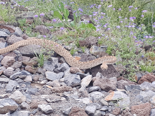
Tan, before returning to the parking lot on Moonlight trail. Plenty of wildflowers were in bloom along the 6.5 km trail, and we enjoyed the beautiful vistas of the San Tan Mountains and the many cacti. With the amount of rain this part of Arizona received this winter cacti seemed to have decided it was safe to add some growth: everywhere the tips of the saguaros had a silvery shimmer from new spines still folded over the crowns of the plants, and the jumping chollas almost seemed to glow on this cloudy day. 

Again I noticed, as so often, the many birds singing here in the desert. It always amazes me that it is so more prominent than in the forested areas where we hike. This park, with very few visitors when we were there but likely well used at other times since it is so close to the Phoenix area, is a great place to hike and an alternative to the Superstition Mountains if you want to do something different. 


From San Tan it was only a short drive now to Mesa where our friends were awaiting us already. It felt strange to sit inside, but it was just too cold to enjoy the evening outside on the patio. Hopefully things would change for the excursions we had planned for the next couple of days.